
The SHERPA report, Framework providing definitions, review and operational typology of rural areas in Europe, showed that the term ‘rural’ is widely defined but there is no consensus on the central components of its definition. One of the difficulty encountered by scientists and policy-makers is to take into account rural areas’ diversity and to grasp their geographical, economic, societal, environmental and cultural characteristics. It is thus necessary to select indicators to characterise rural areas in order to understand the drivers of change and the main trends that affect their development.
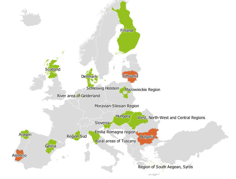
Thanks to the Multi-Actor Platforms (MAPs) set within the SHERPA project (Figure 1), we identified seven topics to be considered when characterising rural territories (see also the Discussion Paper on the Long-term vision for rural areas):
- demographic shift;
- climate change and environmental services;
- shift in production;
- infrastructures and services;
- digitalisation;
- inequalities and wellbeing; and
- land use.
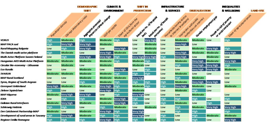
For each topic, we reviewed available datasets at both European and national levels with the help of the MAPs (Eurostat and national statistics offices). Overall, we selected a set of twelve indicators that matched the condition of being available for most countries and at the spatial resolution of small regions (NUTS 3 level).
For each MAP and each indicator collected, we then calculated the deviation from the European average. Table 1 below shows the quartile in which falls the indicator for each MAP.
The key evidence we can extract from the results is that the MAPs represent a diversity of socio-economic and environmental contexts. Actually, the MAPs cover both low (Bulgaria, Finland, Lithuania, Romania, Greece, Spain) and very high (Netherlands) population density, while also representing the diversity of territories in terms of population ageing.
Some areas will be very highly affected by climate change compared to the European average (France, Bulgaria, Finland, Spain, Italy) while others will not be as much (Denmark, Lithuania, Germany, Poland).
SHERPA Multi-Actor Platforms represent a diversity of socio-economic and environmental contexts.
The rural economies are also diverse: from territories with a high Gross Domestic Product (GDP) per capita but a moderate Gross-Value Added (GVA) from the agricultural sector (Denmark, Germany) to territories with a low GDP but a high agricultural GVA (Bulgaria, Romania).
From the table, we can also see how diverse the access to basic services and the degree of digitalisation are across Europe. Moreover, some MAPs have a relative high proportion of people at risk of poverty compared to the European average despite having a higher GDP per capita (Germany), while the other end of the spectrum is also represented (Czech Republic), highlighting different levels of inequalities. Interestingly, the MAPs also cover territories that have a very high share of agricultural lands but a low GVA from the agricultural sector (Denmark), and territories with an agricultural sector that represent a low share of land but a high share of GVA (Spain).
Although this analysis enables us to show certain characteristics of rural territories, there are still many indicators missing, which would be necessary to grasp the rural diversity. In fact, while collecting data for this work, MAPs also suggested their own sets of indicators to characterise their territories. Their review shows that new sources of data should be collected to include current trends.
This work is a preliminary step that will be expanded within the SHERPA project, with the mapping of trends, policies and strategies relevant to rural areas (Task 3.3).